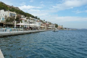
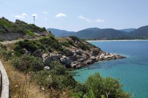
The photo was shot using a NIKON D90 camera at an aperture of f/10, 1/400 sec. shutter speed and ISO 250. AF-S DX VR Zoom-Nikkor 18-105mm f/3.5-5.6G ED lens was used to capture the image. Flash did not fire.. The original image file has a resolution of 4235 x 2813 pixels, or in other words 11.9 megapixels.The photo has a resolution of 240 DPI.
According to the image metadata, the photo was shot on Tuesday 23rd of June 2015. The local time was 14:59:22. The timezone was Europe / Istanbul, which is GMT +03:00. Please note that timezone was guessed using the GPS coordinates and may not be accurate. The EXIF timestamp may also be wrong if the date and time weren't set correctly in the digital camera.
NIKON D90 camera has a built-in GPS receiver and allows geotagging on image files. The coordinates and location where the photo was taken is stored in the EXIF. According to GPS data analysis, the photo was taken at coordinates 39° 47' 29.57" N , 26° 3' 46.19" E. The elevation was 6 meters. Using reverse geocoding, the address associated with the coordinates is guessed as Cumhuriyet Mahallesi, Kıymet Sokak No:26, 17680 Bozcaada/Çanakkale, Turkey. Depending on the GPS receiver and the reception conditions the accuracy may vary and the address should not be regarded as exact location.