The photo was shot using a SONY DSC-HX50V camera at an aperture of f/4, 1/25 sec. shutter speed and ISO 800. 4.3-129mm f/3.5-6.3 lens was used to capture the image. Flash did not fire, compulsory flash mode. The original image file has a resolution of 5184 x 3888 pixels, or in other words 20.2 megapixels.The photo has a resolution of 350 DPI.
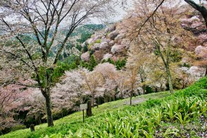
According to the image metadata, the photo was shot on Friday 7th of November 2014. The local time was 06:58:56. The timezone was Asia / Tokyo, which is GMT +09:00. Please note that timezone was guessed using the GPS coordinates and may not be accurate. The EXIF timestamp may also be wrong if the date and time weren't set correctly in the digital camera.
SONY DSC-HX50V camera has a built-in GPS receiver and allows geotagging on image files. The coordinates and location where the photo was taken is stored in the EXIF. According to GPS data analysis, the photo was taken at coordinates 34° 12' 47.40" N , 135° 35' 40.88" E. The elevation was 835 meters. Using reverse geocoding, the address associated with the coordinates is guessed as Japan, гЂ’648-0211 Wakayama-ken, Ito-gun, KЕЌya-chЕЌ, KЕЌyasan е›ЅйЃ“371еЏ·з·љ. Depending on the GPS receiver and the reception conditions the accuracy may vary and the address should not be regarded as exact location.


